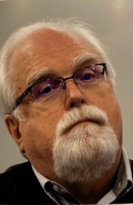
John S. Jacob, Ph.D.
Course Instructor

Dr. John Jacob is a gifted teacher with over 30 years of lecture and practice in the areas of watersheds, wetlands, and soils.
Jacob is Professor and Extension Specialist Emeritus with the Texas A&M AgriLife Extension Service through the Department of Recreation, Park, and Tourism Science. He founded and directed the Texas Coastal Watershed Program, now the Texas Community Watershed Partners.
In retirement, he continues to teach, and divides his time between Guatemala and Houston.
Jacob holds B.S. and M.S. degrees from Texas Tech University, and a Ph.D. from Texas A&M University, all in soils and natural resources. He is registered as a Professional Geoscientist (soils) with the State of Texas and is a Professional Wetland Scientist.
Jacob has taught soils and wetlands for over 30 years. He has collaborated on research on these issues and is a co-author on several significant publications.
Jacob developed the Coastal CHARM (Community Health and Resource Management) model, which enables coastal communities in Texas to improve quality of life in cities and towns while preserving and enhancing the natural coastal environment.
Jacob is a recognized expert on Texas wetlands, having been active in consulting and research aspects of wetlands for more than 30 years. Jacob is co-author of the Texas Coastal Wetland guidebook, as well as the Texas A&M Resilient Coast series on the built environment and wetlands.
Past projects include the development of the “Eco-Logic” Habitat map of the 8-county Houston region. Jacob was a lead participant in one of the first published research projects following the Supreme Court Rapanos decision addressing the issue of the hydrologic (and therefore regulatory) significance of a large class of wetlands on the Upper Gulf Coast of Texas. Most recently, he and his staff developed the CHARM model, a GIS-based user-friendly model that enables users to develop growth scenarios and to see in real time the effects of their choices in terms of ecosystem services, for example. Part of this project involved perfecting the “weTable”, an innovative high-tech, low-cost participatory GIS platform.3